The Hybrid Network Model calls for a Water Ecosystems
Paradigm Shift in the Vietnamese Mekong Delta / El modelo de red híbrida exige
un cambio de paradigma de los ecosistemas acuáticos en el delta vietnamita del
Mekong / Modelos de redes territoriais e transformações socioecológicas no
delta do Mekong, no Vietnã
Nguyen, Sylvie Tram1
1.
Wageningen University Research, Soil Geography and Landscape Group, The Netherlands,
sylvie.nguyen@wur.nl, https://orcid.org/0000-0002-6619-5555
Received:
07/03/2025
Accepted:
28/08/2025
DOI:
https://dx.doi.org/10.12795/astragalo.2025.i40.09
Abstract
As one of the
world's largest rice exporters and most vulnerable low-lying deltas, the
Vietnamese Mekong Delta (VMD) has undergone radical territorial transformations
primarily for agricultural purposes. However, human-induced water
techno-managerial changes, coupled with climate change and sea level
rise—causing flooding, drought, salination, subsidence, and biodiversity
loss—have disrupted the Delta’s natural processes. This research investigates
how these alterations exacerbate climate change impacts by analyzing
human-induced fabric patterns. Employing Corboz’s Palimpsest method, a
mapping analysis identified three dominant territorial configurations: 1) Star
Node Connectivity, 2) Agrarian Grid Compartmentalization, and 3) Hybrid
Diffusion. The Star Network Model aligns with Desakota rururban patterns
observed along water infrastructure. The Gridded Network Model emerges from
large-scale hydraulic projects that fragment water ecosystems. The Hybrid
Network Model integrates built and natural landscapes, revealing adaptation
potential. While the other two models inadvertently disrupt natural systems,
the Hybrid model inclines to prioritize water and infrastructure in
constructing diversified ecosystems, thereby providing insights into future
resilience strategies. The study proposes reframing these models as Social
Ecologies to foster resilience through a paradigm shift wherein the Mekong
Delta is regarded as a subject and agency within the Ecological Transition.
Thereby integrating livelihoods, and infrastructure in harmony with the Delta’s
natural ecosystems. The findings regarding the Network Models facilitates an
understanding of anthropogenic impacts across the territory and approaches to a
more resilient Mekong Delta.
Keywords: territorial
alterations, climate change resilience, social-ecologicies, network models,
Mekong Delta adaptation
Resumen
El delta
vietnamita del Mekong (DMV), uno de los mayores exportadores de arroz del mundo
y uno de los deltas más vulnerables, ha sufrido alteraciones territoriales
radicales para la agricultura. Sin embargo, los cambios inducidos por el
hombre, junto con el cambio climático y la subida del nivel del mar —que
provocan inundaciones, sequías, salinización, hundimiento y pérdida de
biodiversidad—, han alterado los procesos naturales del delta. Esta
investigación examina cómo estas alteraciones agravan los efectos del cambio
climático mediante el análisis de los patrones del suelo inducidos por el
hombre. Utilizando el método del Palimpsesto de Corboz, un análisis
cartográfico identificó tres configuraciones territoriales dominantes: 1)
Conectividad del Nodo Estrella, 2) Compartimentación de la Red Agraria, y 3)
Difusión Híbrida. El Modelo de Red en Estrella se alinea con la urbanización al
estilo Desakota a lo largo de la infraestructura hídrica. El Modelo de
Red Compartimentada es el resultado de proyectos hidráulicos a gran escala que
fragmentan los ecosistemas acuáticos. El Modelo de Red Híbrida integra paisajes
construidos y naturales, revelando el potencial de adaptación. Aunque todos los
modelos han perturbado involuntariamente los sistemas naturales, proporcionan
información sobre futuras estrategias de resiliencia. El estudio sugiere
replantear estos modelos dentro de los marcos de los sistemas
socioecológicos para fomentar la resiliencia mediante la integración de los
medios de subsistencia, las infraestructuras y los ecosistemas naturales. Las
conclusiones pretenden mitigar los impactos antropogénicos y apoyar un Delta
del Mekong más adaptable.
Palabras clave: alteraciones territoriales, resiliencia al cambio climático, sistemas
socioecológicos, modelos de red, adaptación del delta del Mekong
Resumo
O Delta do Mekong
vietnamita (VMD), um dos maiores exportadores de arroz do mundo e um dos deltas
mais vulneráveis, passou por alterações territoriais radicais para a
agricultura. No entanto, as mudanças induzidas pelo homem, juntamente com as
mudanças climáticas e o aumento do nível do mar — causando inundações, secas,
salinização, subsidência e perda de biodiversidade — interromperam os processos
naturais do Delta. Esta pesquisa examina como essas alterações exacerbam os
impactos da mudança climática por meio da análise dos padrões de terra
induzidos pelo homem. Usando o método Palimpsesto de Corboz, uma análise
de mapeamento identificou três configurações territoriais dominantes: 1)
Conectividade de Nó Estrela, 2) Compartimentação de Grade Agrária e 3) Difusão
Híbrida. O modelo de rede em estrela se alinha à urbanização no estilo Desakota
ao longo da infraestrutura hídrica. O modelo de rede em grade resulta de
projetos hidráulicos de grande escala que fragmentam os ecossistemas aquáticos.
O modelo de rede híbrida integra paisagens construídas e naturais, revelando o
potencial de adaptação. Embora todos os modelos tenham interrompido
involuntariamente os sistemas naturais, eles fornecem informações sobre
estratégias de resiliência futuras. O estudo sugere a reformulação desses
modelos dentro das estruturas do Sistema Social-Ecológico para promover
a resiliência por meio da integração de meios de subsistência, infraestrutura e
ecossistemas naturais. As descobertas visam mitigar os impactos antropogênicos
e apoiar um Delta do Mekong mais adaptável.
Palavras-chave: alterações territoriais,
resiliência às mudanças climáticas, sistemas socioecológicos, modelos de rede,
adaptação ao Delta do Mekong
1.
Introduction: The Mekong Delta and Anthropogenic Transformations
As a low-lying Delta, the Vietnamese
Mekong Delta (VMD) is one of the third-largest Deltas on Earth. Due to its high
agricultural production, the Mekong Delta is a densely populated region of over
17 million and a significant global and regional food security hub (Schmitt and
Minderhoud 2023). Known as the ‘Ricebowl’ of Vietnam, the VMD has undergone
radical territorial alterations to convert its Deltaic landscapes into
agriculture. Since the 1990s, it has become one of the world's largest rice
exporters, with a 50% National yield and 80% total exports. Despite this
success, it has come at the cost of systemic ecosystem loss resulting from
imposed engineering structures, which have obliterated the Delta’s natural
regenerative ecosystem processes (Scown et al., 2023), exacerbating the impact
of climate change and sea level rise, with vulnerable areas in Deltas
experiencing heightened levels of flooding, drought, salination, subsidence,
loss of sedimentation, and biodiversity loss (Scown et al. 2023, Syvitski et
al. 2022, Syvitski 2008, Edmonds et al. 2020).
The Mekong
Delta’s former regenerative processes, once aligned with ecological values
based on deltaic ecosystems, have almost been completely obliterated in favor
of models in water technological and managerial processes in hydraulic
engineering. Investments in optimized ecosystem services in favor of
agricultural production have propelled agrarian progress and transformed the
Mekong Delta into an efficient food production region, at the expense of the
Delta’s water ecosystems. And the Delta’s natural ecosystem processes have consequently
become compounded by the combined impact of these human-induced alterations and
adverse climate change trends, including flooding, drought, salinization (Eslami et al. 2021), sea level rise, and other anthropogenic processes
like reservoir dams, sand and groundwater extraction, and pesticide use,
causing decreased sedimentation (Kondolf et al. 2018),
increased tidal flooding (Eslami et al. 2019),
and accelerated land subsidence (Minderhoud et al. 2017; 2020). The combined pressures threaten the future of the Mekong
with drowning and call for decisive actions (Eslami et al. 2019).
Consequently, the research seeks
to elucidate the types of territorial configurations or fabric patterns that
have been shaped by human-induced processes across the Mekong Delta.
Furthermore, it investigates the underlying agencies responsible for these processes
and their transformative impact on the delta’s natural ecosystems.
2. Brief historical overview of
the Mekong Delta’s transformation
Centralized and decentralized
mechanisms driven by investment in hydraulic technology and managerial water
policy (Evers et al. 2009) have radically altered the delta, consequently
transforming its territory against the laws of nature. My research findings
reveal different resulting territorial configurations—defined here as Network
Models—which have emerged due to key historical events. From the dredging of
the first navigational canals during the early French Colonial period in the
1880s, to the artificially devised watershed management zones by 1975, new
water lines have been incrementally added. Which followed by the expansion of
these irrigation systems with added hydraulic projects composed of dikes,
sluice gates, and pumping systems, during the Green Revolution in the '90s, and
larger-scale hydraulic projects to mitigate adverse environmental impacts by
the early 2000s.
Key historical events have
incrementally driven the delta’s water territorial transformation. The first
traces of canals were set in place during the Nguyen Dynasty (Le Coq, Trébuil
and Dufumier 2004) and the first navigational canals were dredged during the
French Cochinchina period as primary canal systems planned for easy water
traffic navigation between urban centers (Brocheux 1995; Biggs et al. 2009; Biggs 2010).
However, the most rapid progress in canalization occurred after the Vietnam War
in 1975, due to political shifts that advanced water technological and
managerial ingenuity. Nevertheless, since water engineering knowledge was
transferred from the new Central Government located in the North (Arwin van
Buuren 2019; Minkman Buuren, and Bekkers, 2021), it was far removed from the
local ecological wisdom shared by the locals living in the Delta over the last
century (Ehlert 2012; Liao et al. 2016). Moreover, new agrarian production
incentives promoted the postwar movement to the Southern Frontier, whereby
farmers returned to the countryside (Le Coq, Trébuil and Dufumier 2004).
New knowledge of water management was
promoted by the Dutch Water Sector through high-level bureaucrats and
implemented by embassies and engineering consultants to translate the Dutch
Delta Approach (DDA) (van Buuren 2019). Thus, Newfound
DDA in the Netherlands was transferred to the Mekong Delta as one of the first
Southeast Asian countries to successfully adopt the Dutch water management
plans, first during the establishment of the Mekong Delta Management Plan (MDP)
in the 1970s and further after the renewal of the bilateral collaboration
between the Dutch and Vietnamese in 2008.
In these ways, the 1975 reunification
and subsequent 1986 Doi Moi reform period led to land management changes in
support of a Green Revolution. From the campaign for National food security to
the episodes of devastating flood events, the emergent state of fear raised
after the war had driven investment in water infrastructure advancement. The
subsequent campaign to dredge canals and reform water policy changed the
positions of power, by promoting the Green Revolution in the 90s, becoming a
major political shift thereafter (Brocheux 1995; Biggs et al. 2009).
Although these new reforms profoundly
improved the Delta’s water ecosystem through productive processes, they
unintentionally turned ecosystem processes away from the Delta estuary’s
natural cycles. In response to increased flooding and demand for rice production,
canals were extended and mechanized by the late 1990s. Access to new
infrastructure consequently attracted unplanned waterfronting linear urban
settlements, which exerted pressure on them. Hence, processes once in tune with
the cyclic cycles of the monsoon in wet and dry seasonal patterns had been
superseded by more predictable unnatural processes, in favor of flood
protection for safe habitation and revenue in mass rice production. New
progress in technical mechanisms included the coordination of irrigation
channels incorporated with sluice gates, pumping stations, weirs and dikes (Le
Coq, Trébuil and Dufumier 2004).
Furthermore, States of the
Anthropocene, encompassing subsidence, salination, water pollution, groundwater
depletion, and sedimentation loss, were increasingly felt by the late 1990s and
early 2000s. All of which were anticipated in subsequent Mekong Delta
Management reports: NEDECO, Mekong Delta Plan and Mekong Delta Integrated
Regional Plan (NEDECO 1993; The Socialist Republic of Vietnam and the Kingdom
of the Netherlands 2013, 2020; Toan 2014). Despite these warnings, the
agricultural sector continued to suffer the consequences of environmental
degradation well into the 2010s, from water pollution to soil contamination,
questioning the Mekong Delta’s complete devotion to intensified rice
production.
3. Hypothesis and Perspective
Following Vietnam’s Green Revolution,
the process of water resource extraction and land appropriation completely
altered the state of the Delta's water ecosystem. Moreover, the appropriation
of territory as spaces for production and habitation created different deltaic
formations. Different configurations are identified as our ‘Network Models’ and
characterized as overlapping and competing spatial formations composed of fabric
patterns. These research findings shall be further elaborated on from our mapping
analysis in subsequent sections.
It is hypothesized that the gradual formation
of these Network Models has increasingly ignored the Mekong Delta’s natural
water ecosystem, in favor of systematic progress. This points towards a need for
a paradigm shift to address the Mekong Delta’s heavily altered water management
system. To reverse this trend, the Mekong Delta must be recognized as a subject
of Ecological values, rather than the object of ecosystem services. In
the effort to prevent the further state of Anthropocene, the Delta must act as
an active agent in its land and waterscapes. Only by reversing the gaze could
the Delta reclaim its role in sustaining resilient Social Ecologies.
To foster an Ecological Transition
between human and natural processes, leading to their integration into a second
nature, strategic novel approaches must be devised. By reframing the Delta as
an agency for the Ecological Transition, the research focuses on building an
understanding of the spatial anthropogenic changes made across the region and
the different agencies behind them, as a catalyst for strategic Deltaic
adaptation. Therefore, identified Network Models shall be extracted to be
further investigated and characterized through the palimpsest analyses.
Emergent patterns found in the Mekong Delta’s fabric shall present the
construction of layers over time, to build narratives of how the Mekong Delta
has arrived at such an Anthropogenic structure.
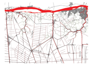
Figure 1 shows the location of the
detailed study area, located in the upper alluvial region of the Mekong Delta,
directly south of the Bassac River and the Long Xuyen Quadrangle[1] and Can Tho. The
middle image in Figure 1 shows the zoomed-in case study area. And to the
right, the detailed study area is shown; for clarity, the frame has been
rotated north-west, and covers part of the Long Xuyen Quadrangle and Can Tho
region. Therefore, all the mapping studies in this section shall be based on this
frame.

Figure 1.
Study area location map, set in Long Xuyen Quadrangle and the western portion
of Can Tho province. Source: Author 2022. Datasource:
Google Earth accessed 2019, OpenStreet-Map, accessed 2019.
When
the first traces of canals were dredged before the 1800s, sparse linear
settlements colonized the edges of the canals as natural sedimentation built up
on both sides, creating a natural protection area from the rising waters. The
diagrammatic section in Figure 2, shows the hypothetical relationship of the
first stilt houses along the canal embankments, surrounded by forested areas. Ricefields,
most likely cultivated as floating rice paddies, were likely cultivated in the
swampy land beyond.

Figure 2.
Diagrammatic canal section in the 1800s, with levees colonized by stilt houses
and forest.
Figure 3 illustrates the evolution of
water networks and urban growth over the decades. The map in the 1930s depicts how
the first traces of canals were dredged over the swampy landscape, original
alignments which has remained largely unchanged. By 1988, secondary and
tertiary canals were constructed, and sparse linear settlement development emerged
along the main canal corridors, and primary roads were planned alongside
canals. In 2003, the nodal town expanded along with the principal city of Can
Tho, and linear settlements further developed along primary canals. By 2016, rapid
urban development and increased linear intensification along most canals exerted
more pressure on existing conditions.

a.
1930

b.
1988

c.
2003
4. Research Methodology
Please be advised that the subsequent
mapping analysis in the following section shall not be based on a chronological
sequencing of the territory. Instead, Network Models shall be identified and
extracted from the fabric based on the hypothetical relationships established
by different agencies. As such, the justification of transformations shaping
the new Delta shall be made through identified actors found therein. This
approach of defining Network Models between configurations of urban spaces,
elements, and layers of pattern formations ultimately identifies newfound
heterotopic relationships, drawing inspiration from David Grahame Shane's urban
design methods in conceptual modeling (Shane 2005, 2021).
The research method is based on a
layered mapping approach, adopted from Corboz’s land in Palimpsest
methodology (Corboz 1983), which is built upon the superposition of layers of
historical constructs, and the use of figure-ground concepts based on Colin
Rowe’s Collage City (Rowe and Koetter 1978). For instance, novel forms
of boundaries, spaces, or limits were identified to have taken shape due to
different water controls across the territory, pushed by various centralized
and decentralized mechanisms. Driven by various geopolitical agencies, these processes
have transformed the Mekong Delta's once deltaic ecosystem, resulting in different
fabric patterns.
The anthropogenic relationships
created distinct forms of rationalities whereby various boundaries were set
apart, as illustrated in Figure 4. They have emerged from intricate Social
Ecological interactions between the Delta's ecosystem and various processes,
including urbanization or industrialization progress, technological
advancement, and social or societal interactions. Through a layered mapping
analysis of the territory, three distinct figures of territorial development
were identified. Each of these models exhibits unique configurations, albeit with
overlapping elements. As mapped in Figure 4, each network model was extracted
as a diagram, which serves as a conceptual abstraction of the traces that have
ultimately shaped the Delta’s development pattern.
Consequently, the research has identified
three distinct territorial configurations prevalent across the Delta region,
collectively referred to as Network Models, as illustrated in Figure 4.
These resulting models were shaped by diverse actors and agencies and have been
categorized into three distinct types: Network Models of Stars, Grids, and
Hybrids. A description of each Network Model is provided below:
1) Stars, Nodal Connectivity
The activities linkages, attracting urban growth between
the urban-rural territories, specifically along key water and road corridors.
2) Grids, Agrarian Compartmentalization
Irrigated fields, resulting from centralized and
decentralized water management for rice production, led by hydraulic societies.
3) Hybrids, Urban-rural Diffusion
The diversified landscapes, comprised of farming units
inhabited by riverine-based locals, combining elements from Stars and Grids.

Figure 4. Conceptual
diagrams of network models: Stars, Grids and Hybrids (top to bottom). Source: Author, 2022. Datasource: Google Earth accessed 2019,
OpenStreetMap, accessed 2019.
5. Results of the Palimpsest Atlas
Analysis
5.1 Network Model 1: Star Node
Connectivity
In the context of navigation and
trade, the first canals were dredged by the French Colonies for strategic water
navigation purposes, they were planned to link trade centers and urban towns.
These canals were designed as radiating networks that intersected urban centers
and linked across the Bassac River and seaports. The canals were designed based
on traffic flow capacity, informed by road transportation planning principles.
The linkage between nodal towns established at joint water and land intersections
was therefore planned similarly to roads. Whereby, the water channels
facilitated transportation by directly linking towns to industrial, market, and
trade zones. Which resulted in the formation of many radial stars and axial
corridors between destination nodes, liken to the boulevards found in Paris
(Brocheux 1995; Biggs 2010). Therefore, the original rationale of canalization
during the French colonial period deviated from the natural logic of the
delta’s floodplains in favor of water navigation.
In addition, various points of
intersection have historically functioned as floating markets, serving as local
meeting points whereby merchants directly sold their goods from their boats,
mainly fruits, vegetables, and other food items. However, water commerce
activities were supplanted by 1916 due to competition with the established
Chinese communities engaged in water trade in South-East Asia. Thereafter, the
French colonies switched from water-connected commerce to road-linked,
land-based commerce activities (Brocheux 1995).
Defined as a Star Network Model,
Figure 5 illustrates the expansion of urban nodes and linear spatial
development across canals and roads as the Postcolonial fabric. This fabric is
characterized by the further growth and extension of established urban centers
and town plans at the intersection of primary canals. Nodal and linear
settlement growth at town intersections and along extended networks of roads
along the canals has further intensified. These networks have activated
linkages between places of interchange, facilitating the flow of people, trade,
commerce, industry, and floating markets. A closer look at the mapping reveals
how ad hoc linear settlements have thickened along the water canals and upon
the parallel and interconnected road networks, establishing another solid
interaction between water-driven and land-based activities.
The linear settlements along roads
and canals between nodal towns have significantly intensified over the decades,
establishing a whole new logic of urban-rural dynamics. This new dynamic has
resulted from the activation of infrastructural linkages between activities
located on and off the waterfront and on land. The formation of star and nodal
towns was planned within a walking radius of approximately 500 to 1km between
service centers. This strategic planning had attracted additional ad hoc formal
and informal linear development composed of mixed-use shophouses, accompanied
by ground-level services, including shops, markets, restaurants, and other commercial
activities.
Over time, the original nodal towns
established at the intersection of canal channels have further expanded, as
shown in Figure 6. Sprawling new linear development has emerged and is
dispersed across new secondary and tertiary water channels. The Linear settlement
originally established along the original canals has become denser with added
development, some of which is located along new internal road networks.
Activated by work-live activities, they have further grown and thickened across
the fabric, especially along the linkages near the main town centers. In this
area, the development has become thicker across multiple layers, where roads
and infrastructural networks were added. This thickening creates a palimpsest
of linear settlement patterns, which enhance the identity of the established
water channel networks while adding more pressure to land-based development,
particularly along roads.
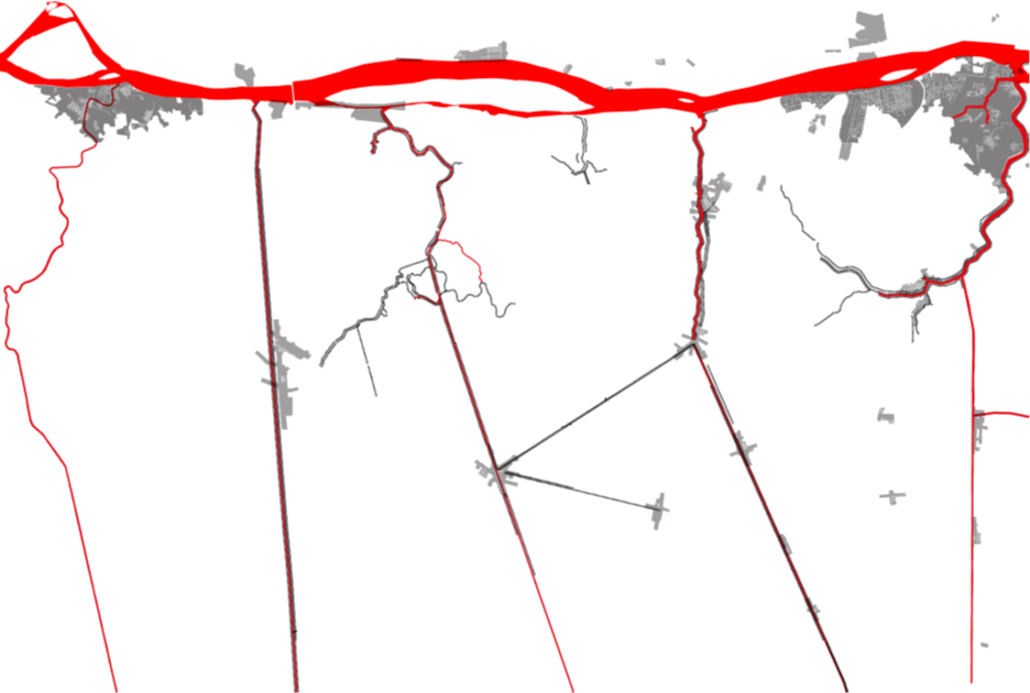
Figure 5. Star canal
formations and expansion of urban nodes through linear development along the
colonial era canals. Source: Author, 2022. Datasource:
Google Earth accessed 2019, OpenStreetMap, accessed 2019.
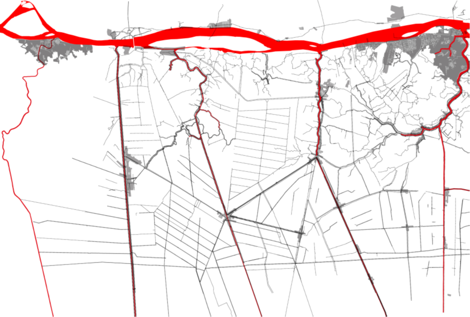
Figure 6. Map
showing the expansion and densification of linear settlements between original
nodal towns, enhancing the radial network linkage at the intersection of canals
and towns. Source: Author, 2022. Datasource:
Google Earth accessed 2020, OpenStreetMap, accessed 2019.
Figure 7 shows how one of Co Do's
original nodal towns has expanded as a star formation, and linear settlements
have intensified along its canals over fewer than 20 years. Similar to the
switch from water to land-based activities identified by Phuong Nga’s mapping
of the Cai Rang waterfront community in the Mekong, the mapping shows how the
valorization of infrastructural investment in roads (doubled up from dikes) has
resulted in a turn away from waterfront activities and onto road-oriented
communications networks (Nguyen 2015).
In 1998, several remote roads were
constructed with linear settlements along the secondary canals. By 2002, the
activities had thickened in multiple layers along the north-south axis, along
the canal, and the linear settlements had expanded through the addition of road
networks that provided more access along the star webs of canals. By 2014,
large-scale developments had been planned along the web of water and road axes,
encroaching upon the agricultural fields. These new plans have provoked more
intensification not only along the axis but along the web axis, further shaping
the star pattern. By 2020, this pattern becomes filled, as the secondary canals
become more intensified with double-sided linear development and the blocks
become more fully developed.
In the 1960s and 1970s, the term
“rururbanization” was coined in France (Barcelloni and Viganò 2022), to
describe the rapid urban flight into the rural areas. This phenomenon was
further defined by Paola Viganò, as a response against the formal urban policies,
leading new villagers to construct their own homes, densifying the countryside.
Similarly, Terry McGee identified the Desakota phenomenon in South Asia
during his subsequent research (McGee 2009). Revisiting South-east Asia's Urban
Fringe, McGee reassessed the challenges of Mega urbanization, discovering a
similar dynamic, albeit within agrarian land. Known as 'city–village,' Desakota
is a phenomenon whereby the extended built area located between the agrarian
landscape is driven by the following activity flows:
"Distinctive areas of
agricultural and non-agricultural activity are emerging adjacent to and between
urban cores, which are a direct response to pre-existing conditions, time-space
collapse, economic change, technological developments, and labor force change
occurring in a different manner and mix from the operation of these factors in
the Western industrialized countries in the nineteenth and early twentieth
centuries." (Ginsburg et al. 1991)
Several authors have already
identified the Desakota Phenomenon in the Mekong Delta region, (Desakota Study
Team 2008, McGee 2009, Shannon and De Meulder 2012, De Meulder and Shannon
2018, Lawson, Guaralda and Nguyen 2022). However, this study distinguishes
Desakota activities through specific land pattern formations, defined as the
Star Network Model. This phenomenon aligned with Desakota culture, as the
linear water and parallel road network linkages attract rapidly growing ad hoc
activities, situated between urban and rural areas. This Star Network Model is
created by a hierarchy of radial linear settlement expansion patterns activated
by access to intersecting water and road infrastructure. These radial
connections provide access to economic and industrial infrastructure or
activities.

Figure 7. The expansion
of the original colonial era Star model located in Co Do town over the last 18
years. Image a. 2002; b. 2007; c. 2014; d. 2020. Source: Author, 2022. Datasource: Google Earth History 1996, 2002, 2014, 2020 accessed
2020, OpenStreetMap, accessed 2019.
5.2 Network Model 2: Gridded
Compartmentalization
By the 1990s, the Green Revolution
had established a comprehensive hydraulic irrigation system consisting of
canals, water channels, dikes, sluice gates, and pumps. Defined as a Grid
Network Model, Figure 8 shows an agrarian irrigation system composed of gridded
compartments, wherein a hierarchical system of primary and secondary canals was
devised. Canals and channels were incrementally added as part of a systematic
approach to optimize rice production. This system was enabled through the
drainage or irrigation of fresh water, based on the cultivation requirements of
different rice species. As a result, Figure 8 shows how the homogenous
irrigation system was formed by large-scale hydraulic systems, gridded across
the Delta region. The resulting water grid was driven by a hydraulic society
based on water control for land appropriation and cultivation purposes (Evers
and Benedikter 2009)
In contrast, extensive canals were introduced
during the French colonial period. Initial canals were dredged in Vinh Te, Ha
Tien, Rach Gia, and Long Xuyen, primarily for transportation and military
navigation purposes. While canals were not originally dredged for irrigation
purposes, technological advancements and the demand for flood and food security
shifted the focus of water management from navigation to water irrigation. This
transformation was achieved by extending existing canals and adding new
secondary ones, thereby creating a new water management approach in the
planning.
However, this shift failed to
reconsider the scalar gap between the industrial and local farming scale, as
recommended by the 1993 NEDECO Mekong Delta plan (NEDECO 1993). Investment in
the irrigation system neglected to integrate the water management system to
meet the needs of the farming unit. Consequently, the palimpsest mapping
reveals a large-scale homogenous system, a massive gridded system imposed over
the Delta’s original swamps. Moreover, the agrarian Grid network model reveals
how the entire territory has been appropriated for industrial-scale
agricultural development purposes. This high-level water grid was financed and
developed by the National Vietnamese government and mandated during Vietnam's
all rice production based on a water-oriented policy (Evers and Benedikter 2009).
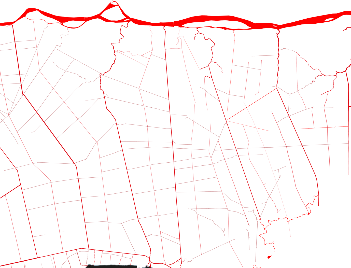
Figure 8. Agrarian Gridded Compartments consisting of an extensive
irrigation system composed of rivers, canals and channels. Source: Author, 2022. Datasource: Google
Earth accessed 2019, OpenStreetMap, accessed 2019.
The basic mechanism for managing
water drainage and irrigation relies on the interplay between the wet and dry
seasons, along with the water and land requirements of the cultivated rice
species. For instance, as illustrated in Figure 9, during the wet season,
floodwaters draw water into the territory from the river channel and primary
canal feeders. If the inundation is too high, the sluice gates located at the
intersection of the primary and secondary canals can be manually closed to
prevent further water ingress. Moreover, raised dike systems along the canals
were designed to contain such wet-season inundations (elevated water levels)
and prevent overflowing into surrounding rice fields. These dikes were
typically raised between 1.5 to 3 meters or more, depending on the flooding
levels. Additionally, central pumping stations may be utilized to pump water
from secondary channels back to primary canals, effectively reversing the water
flow during floods. Individual farmers also used their pumps to direct water
according to their cultivation needs (Biggs 2012). Conversely, the water
irrigation system reverses during the dry season, when water is irrigated or
pumped into the fields. This process is enabled by the same pumping systems;
however, in this instance, the sluice gates may remain open, while certain
gates may be closed to divert water towards areas with higher water
requirements to meet specific irrigation needs.

Figure
9. Basic drainage water flow during wet season.
Source: Author, 2022. Datasource: Google Earth accessed
2019, OpenStreetMap, accessed 2019.
The farming scale, comprising houses
and associated gardens, had evolved from within the larger agrarian structure,
as mapped in Figure 10. Land parcels along the main canals were subdivided for
residential purposes, characterized by extended orchards interspersed within
elongated rice field sections. This landscape pattern has established a common
fabric language. Moreover, the linear settlements have valorized the dual dike
and road infrastructure developed along the primary canal with increased densification.
In addition to the original development along the canal fronts, they have
become even more intensified on the opposite side of the water, where new roads
were constructed. The comprehensive integration of houses, gardens, along
diked-road infrastructure running along the canal, constitutes the thickened
moment, thereby establishing Social Ecologies. These elements are the most
diverse and dynamic elements across the vast, homogenous agrarian fields
beyond.

Figure
10. Habitat and garden scale along the main canal, nested within the agrarian
structure. Source: Author, 2022. Datasource: Google Earth accessed 2019, OpenStreetMap, accessed
2019.
By the 2000s, larger-scale hydraulic
projects were managed through public-private partnerships to enhance irrigation
capacity from double to triple rice crops by further elevating the dikes. Their
project limits are shown in the gray zones in Figure 11. Not only do these
projects augment agricultural production, but they also provide flood
protection. For instance, after the 2010 flood, August dikes were proposed to
complete the irrigation system in An Giang province via planned hydraulic
project areas. These large-scale projects were invested in and managed through
public and private sector cooperation by centrally managed companies, such as
Joint Stock Construction Company No. 40 ICCO 40, and Joint Stock Dredging
Company No. II DRECO II (Benedikter 2014). They were mainly financed by
international organizations, including but not limited to Foreign Direct
Investments (FDI), Official Development Assistance (ODA), World Bank (WB), and
Asia Development Bank (ADB).
The foreign capitals mentioned above
provided aid or loans in response to the development market demands in the
Mekong Delta for various investments. These investments consequently
contributed significantly to the modernization of the Delta. Infrastructure
works encompassed water infrastructure, highways, roads, bridges, and other
works. Following the liberalization period, four major regional irrigation
projects were planned: Long Xuyen Quadrangle (our main study area), the Plain
of Reeds, the Trans-Bassac, and the Ca Mau Peninsula. These different projects
responded to different types of water ecosystems in the region. Hydraulic
projects and subprojects were subsequently planned accordingly, resulting in an
increasingly complex system of canals with associated irrigation channels,
dikes, embankments, sluice gates, and pumping stations. (Benedikter 2014)
The main irrigation projects located
within our Long Xuyen Quadrangle and Can Tho study area include Vinh Te, Cai
San, and O Mon-Xa No Canal, which have been under development for over two
decades. Within the regional Long Xuyen Quadrangle hydraulic project area, the
rapid extension of existing and construction of new dikes in the historical
floodplains has transformed An Giang province into a network of irrigated
fields, thereby safeguarding floodwaters from entering the fields during the wet
season.
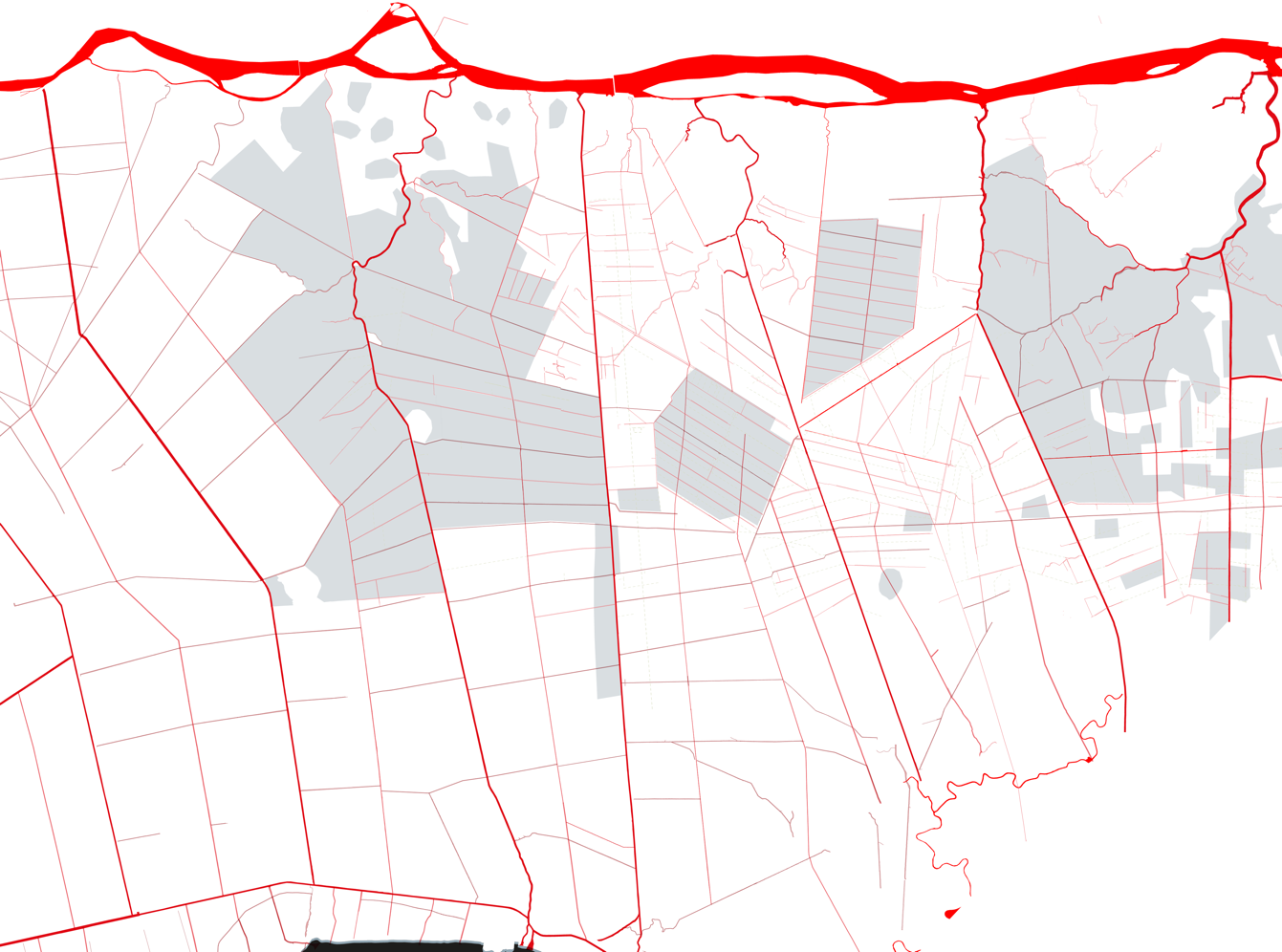
Figure 11. Large-scale hydraulic projects are set as rice
intensification zones found within the gridded agrarian landscape, as shown in
gray. Source: Author, 2022.
Source: Dike routes and diked areas in the Mekong
Delta (Dat 2013) taken from (Nguyen 2015). Datasource: GIS Geodata GMS 2019.
Google Earth accessed 2019, OpenStreetMap, accessed 2019.
5.3 Network Model 3: Hybrid
Urban-Rural Diffusion
Defined as a Hybrid Network Model, these
hybrid zones appear to span between urban-rural infrastructure as blue-green corridors,
as mapped out in green in Figure 12. These corridors are composed of a more
organic fabric, contrasting with the previous Grids Network Model. Within this mixed
area, local activities appear to valorize the combination of natural
environments and irrigation systems for habitat and cultivation purposes. A
diversified landscape characterizes the vast areas of upland crops, which appear
to extend into the agricultural fields.
These diverse landscapes were
predicated on the compatibility of cultivation practices with soil types and the
type of water infrastructure available. Historically, the planting of different
fruit trees was guided by principles of organic agriculture, which were
inherent in the local ecological wisdom of farmers across generations.
Ecological wisdom encompasses the deep understanding of the Delta’s natural ecosystem
processes. Over time, local cultivation knowledge discovered methods of
optimizing the constructed drainage and irrigation system by integrating ecosystem
processes. Through this local practice, crop varieties were meticulously
selected between perennial, annual, and short-term crops. Different species of
crops were rotated based on their environmental compatibility and their monetary
value in local markets.
In particular, this hybrid zone
includes an orchard-based landscape characterized by human settlements that
subsist on the dike system along rivers or canals. These waterfront settlements
are mainly engaged in garden cultivation of upland crops, annual crops, and
various aquaculture. They appear to be concentrated in more protected areas
within the topographically elevated ground along the Bassac River's natural
levee and its main tributaries. This hybrid area spans approximately 6 to 12km
from the river. However, these hybrid zones also emerge around the peri-urban
areas surrounding main cities such as Can Tho, and along artificially elevated
areas, constructed from the resulting mounds left over from the dredging of
canals.

Figure
12. Map showing the hybrid zones of mixed crop cultivation (in green), mainly
in orchards, upland crops, annual crops, and fish farms. These zones appear to
be coupled with intensified urban areas located along the river, in this case,
Long Xuyen City (left) and Can Tho City (right).
Source: Author, 2022. Datasource: Google Earth accessed
2020, OpenStreetMap, accessed 2019.
A detailed examination of the
zoomed-in hybrid zone is shown in Figure 13, which reveals the dual function of
the diked road network as residential access and blue-green infrastructure for
orchard cultivation. Thickened moments of linear urban settlements appear on
both sides of the road, concurrently paired with extensions of diversified
orchard and fruit tree plantations that extend into the agricultural fields. This
suggests the establishment of micro-economic activities that benefit from the
protected elevated areas along the canal embankments. In contrast, less
intensive settlements and orchard areas reside along tertiary streams due to
the limited supporting infrastructure available in these areas.

Figure 13. Map showing a detailed area illustrated by the organic
growth in the hybrid model, characterized by the densification of settlements
along diked road networks with large extensions of orchard cultivation areas. Source: Author, 2022. Datasource: Google
Earth accessed 2020, OpenStreetMap, accessed 2019.
Figure 14 explains the rationale
behind the evolution of development along the canal, as depicted in the
following section. The initially colonized land, which emerged from the
dredging of the canals, subsequently created a natural protective layer along
the canal embankments. This layer, composed of leftover sand from the dredging,
created raised beds that attracted informal stilt housing settlements. The
subsequent intensification of rice cultivation in the fields beyond led to the
introduction of diked embankments directly behind these stilt houses, thereby
creating an irrigation system. This, in turn, attracted land-based houses on
the opposite side of the water, resulting in ad hoc property development there.
These mixed-use houses consisted of elevated land beds for habitation purposes
with shopfronts on the ground, which were further enhanced with orchard
plantations. All these new additions benefited from protection from floods and
access to new networks that connected to other destinations.

Figure 14. Section
showing the upgrade from river stilt housing development along a natural levee
to an embankment raised by dikes on both sides, further constructed as road
access. On the land side of the roads, new modern shophouses were constructed
with raised orchard beds. Elaborated by author.
Figure 15 presents a comprehensive
Palimpsest map of all the Network Models that constitute the study area’s
landscape pattern, in the Mekong Delta. It depicts the interconnected layers as
complex systems and subsystems of the Star, Grid, and Hybrid Network Models.
This palimpsest map comprises all the layers presented before, including the
French colonial canal layers, the hydraulic projects, urbanization patterns,
and diversified Social Ecological landscapes. All these overlapping layers
illuminate the different processes and agencies that have shaped the territory.
These forces driving the Delta are influenced by various powerful agencies that
control water resources. These agencies engage in a dynamic interaction that
"compete, superimpose, and react" as described by Boelen et al.
(2016) as Hydro-Social Territories. Territorial transformations emerging from
overlapping hydrological projects, informal economic activities, and growth
across the urban-rural milieu, and increasingly heterogeneous land cover, have
led to complex interactions. Paradoxically, the Delta’s water ecosystem
services have enabled the very territorial transformations that have
subsequently threatened its natural resources. As defined by Boelen, these
types of hybrid zones undergo constant modification and reorganization across
the territory through the competing actions taken across multiple actors,
actants, and at different scales.

Figure
15. Map showing how overlapping these layers, including French colonial canals,
systems of hydraulic projects, urbanization patterns, and diverse landscapes. Source: Author, 2022. Source: Dike routes and diked areas in the Mekong Delta (Dat, 2013)
taken from (Nguyen, 2015) Datasources: GIS Geodata GMS 2019. Google Earth
accessed 2019, OpenStreetMap, accessed 2019.
Figure 16 shows a more detailed study
area, whereby the identified Network Models of Stars, Grids, and Hybrids were
found to overlap. These overlapping patterns signify the intricate interactions
generated between the top-down managerial operational processes and the
bottom-up local responses to novel resources. The study area has been framed to
clarify the geographic relationship as a Transect. This Transect study (drawn
from left to right) commences from the primary River branch originating from
the Mekong River to the left, proceeds to the natural levee (which spans about
10-15 km), and transitions from the upper alluvial to the lower alluvial plain.
These geographical features provide insights into the locations and utilization
of natural water ecosystems across the Transect.
Figure 16 illustrates how the
phenomenon is driven by the Star Network Model configuration, which is
identified to the right where three major canals intersect. The Omon Town
Channel and Vertical canals converge at the focal point where Thoa Lai Town
center was established. These canals radiate outwards into branches of water
channels, serving as water traffic routes between town centers, approximately 15km
apart. Further along the Omon River, an intricate relationship exists between
the formerly channeled Omon River and a constructed highway (QT922). Whereby
layers of linear Desakota-driven settlement have extended between Omon Town and
Thao Lai Town, connected by the river-highway corridor. This growth pattern encompasses
urbanization and industrial activities that have progressively densified along
the parallel highway connecting the two towns.
Concurrently, the map in Figure 16 illustrates
how the Grid Network Model was formed through the implementation of red
irrigation networks by the Hydraulic Society to promote rice production. These
layers of irrigation channels were superimposed upon the original canals and
watercourses. They were integrated with high dikes (complete with road), strategically
elevated above the flood levels of primary canals and streams. This approach
served as a top-down mechanism to shift the rice cultivation capacity from double
to triple annual harvests.
Conversely, the mixed zones
represented in gray by the Hybrid network model show a propensity for Social
Ecological resilience. This extended gray zone merges the characteristics found
in the other two Network Models. It incorporates the linear settlement pattern
found in Desakota and the valorization of the water networks, which were developed
through the irrigation system. All these elements are intricately combined to
create a mixed-use Hybrid zone. This hybrid zone comprises orchards, family
farming units, and other activities such as shopfronts and aquaculture. It
demonstrates a bottom-up dynamic response to the top-down infrastructural
construction plans. This resilient potential highlights the ability for Hybrid
Network Models to bridge the resources generated from top-down processes with
the local knowledge derived from bottom-up approaches. Which emerges as novel
Social Ecologies with the potential to reframe the challenges inherent in
anthropogenic processes.


Fig. 16. Map of the study area in O Mon and Thoa Lai district, showing the
complex relationship resulting in the overlapping phenomena identified in the
Star, Grid, and Hybrid network models. Elaborated by author. Sources “The
relation between land use and subsidence in the Vietnamese Mekong delta,” GIS
Land Use 2009, Courtesy of (Minderhoud et al. 2018). Datasources: GIS Geodata
GMS 2019. Google Earth accessed 2020, OpenStreetMap, accessed 2019.
6. Discussion 1: STAR Network
Model
The findings from the initial
palimpsest mapping conducted in the Star Network Model underscore the
imperative for further investigation into the accelerated Anthropogenic impact.
Primarily due to the ad hoc linear development activities prevalent across
urban and rural linkages. The identified rapid linear settlement pattern along
water canals and associated roads has indirectly catalyzed artificial
transformations by exerting strain on existing infrastructure. This subsequent
growth was recognized as a Desakota phenomenon, represented by the ad hoc
bottom-up response to water management and infrastructural investment.
Paradoxically, the local farmers’
original “living with the water” paradigm was challenged by the introduction of
diked roads. Thereafter, these road networks attracted Desakota activities,
which rapidly intensified. This inversion, from a history of
waterfront-oriented activities in harmony with the water ecosystem, to
land-based activities turned away from the rivers and canals, resulted in the capitalized
use of land appropriation. Consequently, these activities have become
increasingly alienated from the water system. This phenomenon is exacerbated by
the peri-urban densification, which relies on the installation of flood defense
infrastructure and significant land alterations.
The Desakota culture represents a
glocalized response to the interplay between top-down and bottom-up
urbanization and industrialization processes. This mainly manifests along the
main road and water infrastructure, facilitating communication between urban
and rural areas. Actors leveraging road-based infrastructure gain access to
urban activities through investments made in commerce, services, real estate
development, and industry. These Desakota-oriented endeavors involve shop
owners, families residing in shop houses, traders from designated open markets
at designated centers, and real estate developers. Furthermore, larger
operations drawn by investment in water and road infrastructure include
production-based industries, primarily focused on rice processing, gravel,
sand, and minerals resource extraction, and the transportation or trade of
agricultural yields and construction materials.
The Desakota situation essentially
exploits the interaction between nature and the built systems to support
livelihoods (Desakota Study Team, 2008). Desakota's growth has subsequently
intensified linear urbanization and industrial activities across road networks
between town centers, significantly altering the original land and imposing
environmental strain. The process of building land intensification entails
transforming the land from its natural soil state into compressed soils or
asphalt-covered areas to support building foundations. This, coupled with
densified urban areas, necessitates the provision of fresh water, which is
often extracted through the exploitation of groundwater, leading to land
subsidence (Minderhoud et al. 2018). Moreover, polluted stormwater runoff from
impermeable paved surfaces in urban areas is discharged into designated ground
drainage. Many of these systems release the water back into rivers without
undergoing any treatment, thereby polluting the water and further hindering the
replenishment of groundwater.
7. Discussion 2: GRIDDED Network
Model
Powerful Hydro-politics in the Delta
have shaped the formation of an irrigated land pattern, identified as the Grid
Network Model. The establishment of the Delta-wide canalized water management
system was meticulously funded through agencies in water technological and managerial
operations. Consequently, the water control mechanism facilitated the manipulation
of the Delta into productive agrarian landscapes. These mechanisms were further
enhanced by substantial investment and implementation of numerous large-scale
hydraulic project zones, strategically distributed across the Mekong Delta.
The amalgamation of numerous
hydraulic irrigation projects has shrunken the Delta’s natural watershed by
diverting flood waters into unforeseen areas. These hydraulic interventions have
raised water levels and shortened the inundation period, occasionally diverting
water to vulnerable urban districts such as Can Tho City and Long Xuyen City. A
series of detrimental cycles of anthropogenic impacts also proceed flood
diversion: Previous swamp land prepared for rice production becomes irrigated
land, rendering it incapable of self-cleansing during the flooding season. Consequently,
the soil remains with heightened levels of acidification and a lack of
nutrients due to the absence of sedimentation. Subsequently, necessitating an
increased utilization of chemical treatment due to infertile (acidic) soils,
which, in turn, contributes to water pollution and biodiversity decline.
Planning tools associated with the
implementation of water management policies have transformed the delta’s
floodplains and landscape into a matrix of grid-based agricultural
compartments. These land modifications have introduced another rationality, as
a substantial structure has been superimposed upon the Delta's water
ecosystems. These gridded structures have consequently and inadvertently
obliterated the inherent resilience of the Delta's self-regenerating
floodplains and associated water ecosystem processes.
Lastly, the zoning of the Delta into
agricultural, industrial, and urban areas, as a planning tool focused on
monofunctional land-use planning, has fragmented its natural geomorphology.
Furthermore, as a planning approach based on monetary values, this type of land
appropriation and preparation primarily relies on setting boundaries. As a land
management approach that values land certainty and security, determined by its
monetary yields defined by its land parcelization type, it is unsurprising that
this approach contradicts the Delta's natural cyclical processes. As an
economic land management approach, the Delta management plan completely
overlooks the Delta’s fluid water ecosystems processes, whereby space and time
continuously flow and change with the wet and dry seasons.
8. Discussion
3: HYBRID Network Model & paradigm shift
The palimpsest findings of the Hybrid
Network Model offer a glimpse into the concept of ‘reversing the code.’ This
approach involves a bottom-up process that leverages existing water ecosystems
while simultaneously capitalizing on the top-down investments in irrigation
infrastructure. Unlike the other two models, which result in the further
exploitation of the Delta’s altered water system—Grids through irrigation and
Stars through Desakota—the Hybrid model provides mutual benefits to the Delta, leading
to enhanced landscape diversification. This factor contributes to a more
resilient response to the global economic and industrial forces at play. The
Hybrid Network Model effectively leverages the new infrastructure with existing
ecosystems to produce mutually advantageous combinations of landscapes.
Emerging as a Hybrid Network Model, the
blue-green corridors with extended gardens appear to encroach upon the
agricultural fields. These corridors comprise an interwoven dynamic of
cultivated landscapes and built constructs, where work and living typologies
are adopted. The subsequent local response to large-scale infrastructural
investments involving dikes doubled down as roads, is to harness it into the
locality through small, ad hoc interventions that safeguard habitats
(flood-protected dwellings) and facilitate micro-economies in garden
cultivation. Many of these gardens stem from the waterways and extend into the
agricultural fields, comprising a diverse array of orchards, shrimp ponds,
vegetation, and farm animals.
The resulting hegemonic structure is hypothesized
to be an evolutionary component of the Desakota phenomenon (from the Star
Network Model), with more relevance to local knowledge regarding ecological
wisdom. In addition to farming industries that have profited from the
infrastructural investments made for agriculture, Desakota activities have also
benefited from the transformed water-road networks of the Delta. Furthermore, local
farmers utilized access to network systems to support their farming micro-markets
by cultivating more varieties of crops based on land compatibility. This has resulted
in the interplay between the provision of ecosystem services (soil, fertile
ground, irrigation) and infrastructural capacity (water, sewage, energy).
Although this provision can impose
additional pressure on the territory, possibly leading to anthropogenic impacts,
the intensification between urban and rural linkages across diversified
blue-green corridors holds the potential to transform the currently homogenous fields
into ecologically resilient territories. The Mekong Delta's territorial
relationship between the water channels, urban centers, and land networks presents
an opportunity to adopt new approaches that foster Social Ecological resilience.
Resilience that integrates the water processes, interactions between
institutions involved in water and landscape management, socio-economic interactions
between farmers and traders, various industrial practices in land cultivation
for food production, and more rural-urban drivers. For these reasons, the
research raises the following question:
How can lessons learned in the
Hybrid Network Model inform the redesign of various hydraulic projects, hybrid
land mosaics, and rururban Desakota patterns, to create space for a more Social
Ecologically resilient Delta in confronting the water ecosystem threats in the
Mekong Delta?
9. Discussion 4: The Evolution of
Hybrid Models
The Mekong Delta has entered the
Anthropocene due to the compounded effects of water control enabled by water
management of hydraulic infrastructure, resource exploitation, and intense
land-altering development processes. In response, local farmers and settlements
have further exploited the transformed land, with their agenda for ensuring the
combination of habitat and micro-economies, through live-work garden and pond
cultivation patterns, unintentionally exacerbating the altered state of the
Delta.
The palimpsest study has elucidated
the evolution of three major Network Models over the past decades.
Demonstrating how these models have progressively transformed into increasingly
complex systems and subsystems, albeit inadvertently contributing to the
anthropogenic state. Territorially, the Network Models discovered in Stars,
Grids, and Hybrid patterns exhibit a complex set of dynamics distinguished by
the interaction between local and global driving forces. The palimpsest research
finds that these dynamic fabric patterns have consequently transformed into Social
Ecological combinations. As new combinations, these heterogeneous
configurations are characterized as hegemonic fabric patterns formed over
periods, by various driving forces, all leading to intricate territorial
(re)configurations.
These configurations can either
create more integrated or fragmented relationships across the urban-rural
fabric. When fragmentation occurs, it often reveals a spatial mismatch and a
scalar gap in land-use planning, hydraulic management, and land ownership
patterns. The reconfiguration of deltaic land, particularly to support
intensified zones of agrarian production and urbanization, has exacerbated
environmental impacts, including flooding, salination, erosion, water
pollution, and other factors. Although territorially productive under their
respective agenda, the combination of these models has also contributed to the
environmental challenges faced by the transformed state of nature.
10. The findings in the Hybrid
Model call for a paradigm shift
In contrast to the other two Network
models, the Hybrid Network Model demonstrates resilient Social Ecological
processes that have the potential to reverse the code resulting in
anthropogenic outcomes, thereby illuminating the pathway toward an Ecological
Transition. Reversing the code can be achieved through the progressive
ecological diversification of land and its integration into farmers’ processes
and livelihoods. As illustrated in the section depicted in Figure 15, the
incremental transformation of land from the local utilization of gray
infrastructure networks, in combination with associated dwellings and
cultivated gardens, serves as evidence of beneficial Social Ecological
interactions.
This hybridization of processes,
encompassing the combination of blue-green infrastructure, the Desakota
colonization dynamic, and the diversification of landscape cultivation,
demonstrates existing resilience that remains untapped. This untouched informal
procedure should be integrated into the Delta’s formal territorial planning
process. The resilient land diversification patterns exhibited by the Hybrid
Model necessitate a paradigm shift to further foster the diverse state of
hybrid combinations, regarded as Social Ecologies. By mutually
benefiting rather than exploiting the Mekong Delta’s landscape and water ecosystems,
the Hybrid Model may further develop a multitude of landscape and ecological
combinations and cultivation processes.
Consequently, to work harmoniously
with the Mekong Delta’s ecosystems, a new perspective must be fostered. Instead
of solely focusing on the many agencies that have transformed it over time, we
must post-rationalize the Delta’s natural states and its altered states. To
recognize the Mekong Delta as a ‘terrestrial constituent’ (Bruno Latour 2018)
and agency of change, we must shift the focus from utilizing the Mekong Delta
solely for ecosystem services. Rather than becoming an object of
commodity in ecosystem services, the Delta transforms into a territorial subject
through which to redefine climate change thresholds and promote Social
Ecological resilience. As a social production of material culture, the Delta
equally reacts to climate change’s impact on humans and nonhumans alike.
Therefore, the Mekong Delta’s Water as Subject paradigm shift will
elevate it to an equal territorial actor and participant in the ongoing
discourse of Social Ecological progress (Vigano 2022, Vigano et al. 2023). The
Mekong Delta shall ultimately serve as a catalyst, paving the way for valuable
lessons, informing novel water ecosystem processes, and reframing the climate
change phenomenon towards an Ecological Transition.
11. Concluding Remarks: The urgent
need for restructuring anthropogenic processes identified in the three Network
Models
The three Network Models were shaped
by anthropogenic processes that transformed the Mekong Delta’s estuary characteristics.
The construction of extensive hydraulic works accelerated environmental
degradation by precisely controlling water flow, direction, and quantity through
water pumps, sluice gates, and dikes. This subsequently affected the Delta’s water
and soil quality. Anthropogenic processes began with the division of
floodplains into water management units and the appropriation of swampland for
agriculture. Powerful state actors and private organizations driven by agrarian
production-oriented water policy invested in the agricultural sector. Furthermore,
engineered water techno-managerial projects associated with irrigation were
incrementally planned and constructed, with progressively larger-scale water
works. Lastly, local responses leveraged access to new infrastructure with
natural resources through different land appropriation and cultivation practices.
The palimpsest analysis findings delineate
Grids, Stars, and Hybrid Network Models, thereby answering the research
question regarding territorial configurations resulting from human-induced
processes across the Mekong Delta and the agencies behind them. The Star
Network Model unveils a radial pattern of linear growth along intersecting waterways,
resulting in urban-rural development patterns characterized by Desakota, as intensified
linear settlement development along key infrastructure. This phenomenon shifts
away from the “living with the water” paradigm by capitalizing on land-based
driven densification along network infrastructure. Financed by influential
Hydro-political actors, the Grid Network Model presents large-scale hydraulic
infrastructural networks superimposed in a gridded pattern. Facilitated by advancements
in water technological and managerial procedures, the resulting agrarian
irrigation systems enabled substantial agricultural production. Consequently,
diverting the Delta’s natural flooding patterns hinders the Delta from its self-regenerative
processes. The first two dynamic Network Models emerged from general forces,
the interplay between top-down and bottom-up processes. These interactions generated
territorial dynamics in favor of Hydrological constructs, contradicting the
laws of nature and inadvertently erasing the Delta’s natural states. However, the
Social Ecological resilience emerges from the identified Hybrid Network Model,
which challenges these Hydro-political processes, revealing overlapping patterns
of dynamic Social Ecological resilience. By reversing the code wherein a more
mutual interrelationship is formed between nature and humans, the pattern of blue-green
corridors integrated with productive habitats signifies a shift towards
rethinking the relationship between anthropogenic and natural processes. Therefore,
the Hybrid Network Model’s combination of landscape and built systems presents
an opportunity for Social Ecological Resilience. This proposed paradigm shift, characterized
by the reframing of Water as Subject, transforms the Mekong Delta’s water
ecosystem as agency, thereby facilitating a resilient Ecological Transition.
Interest is taken in the
countercurrent process between top-down and bottom-up forces, as Desakota
coupled with blue-green ecological systems evolve into increasingly hybrid and
heterotopic forms and processes, representing an evolution of Social Ecological
resilience. The central question now revolves around how these actors will
collaborate within this Hybrid Network Model and 'reverse the codes.' Which
entails the reversing of the current exploitation of the Mekong's water
territory into ecosystem services by approaching the Delta’s resilience through
the integration of its inherent ecological values with novel Social Ecologies.
The research findings provide design research recommendations to address the
subsequent question: how can reframing hydraulic projects, hybrid
landscapes, and rururban patterns generate space for a more Social-Ecologically
resilient system in facing the water ecosystem threats in the Mekong Delta?
12.
References
Barcelloni,
Martina Corte, and Paola Viganò, eds. 2022. The Horizontal Metropolis: The
Anthology. Cham: Springer.
Benedikter,
Simon. 2014. “Extending the Hydraulic Paradigm: Reunification, State
Consolidation, and Water Control in the Vietnamese Mekong Delta after 1975.” Center
for Southeast Asian Studies, Kyoto University. https://doi.org/10.20495/seas.3.3_547.
Biggs,
David. 2010. Quagmire: Nation-Building and Nature in the Mekong Delta.
Weyerhaeuser Environmental Books. Seattle: University of Washington Press.
Biggs,
David. 2012. “Small Machines in the Garden: Everyday Technology and Revolution
in the Mekong Delta.” Modern Asian Studies 46 (1): 47–70. https://doi.org/10.1017/S0026749X11000564.
Biggs,
David, Fiona Miller, Chu Thai Hoanh, and François Molle. 2009. “The Delta
Machine: Water Management in the Vietnamese Mekong Delta in Historical and
Contemporary Perspectives.” In Contested Waterscapes in the Mekong Region:
Hydropower, Livelihoods, and Governance, 203–25. 1st ed. USA: Routledge.
Boelens,
Rutgerd, Jaime Hoogesteger, Erik Swyngedouw, Jeroen Vos, and Philippus Wester.
2016. “Hydrosocial Territories: A Political Ecology Perspective.” Water
International 41 (1): 1–14. https://doi.org/10.1080/02508060.2016.1134898.
Brocheux,
Pierre. 1995. The Mekong Delta: Ecology, Economy, and Revolution, 1860–1960.
Monograph / University of Wisconsin-Madison. Center for Southeast Asian
Studies, no. 12. Madison, WI: Center for Southeast Asian Studies, University of
Wisconsin-Madison.
Corboz,
André. 1983. “The Land as Palimpsest.” Diogenes 31 (121): 12–34.
De
Meulder, Bruno, and Kelly Shannon. 2018. “The Mekong Delta: A Coastal
Quagmire.” In Sustainable Coastal Design and Planning. Boca Raton, FL:
Taylor & Francis.
Edmonds,
D. A., R. L. Caldwell, E. S. Brondizio, and S. M. Siani. 2020. “Coastal
Flooding Will Disproportionately Impact People on River Deltas.” Nature
Communications 11 (1): 4741.
Ehlert,
Judith. 2012. Beautiful Floods: Environmental Knowledge and Agrarian Change
in the Mekong Delta, Vietnam. ZEF Development Studies, v. 19. Berlin: Lit.
Eslami,
S., P. Hoekstra, N. Nguyen Trung, S. Ahmed Kantoush, D. Van Binh, D. Duc Dung,
and M. van der Vegt. 2019. “Tidal Amplification and Salt Intrusion in the
Mekong Delta Driven by Anthropogenic Sediment Starvation.” Scientific
Reports 9 (1): 18746.
Eslami,
S., P. Hoekstra, P. S. Minderhoud, N. N. Trung, J. M. Hoch, E. H. Sutanudjaja,
and M. van der Vegt. 2021. “Projections of Salt Intrusion in a Mega-Delta under
Climatic and Anthropogenic Stressors.” Communications Earth &
Environment 2 (1): 142.
Evers,
Hans-Dieter, and Simon Benedikter. 2009. “Strategic Group Formation in the
Mekong Delta: The Development of a Modern Hydraulic Society.” Bonn: Department
of Political and Cultural Change, Center for Development Research, University
of Bonn.
Ginsburg,
Norton Sydney, Bruce Koppel, T. G. McGee, and East-West Environment and Policy
Institute (Honolulu, Hawaii), eds. 1991. The Extended Metropolis: Settlement
Transition in Asia. Honolulu: University of Hawaii Press.
Kondolf,
G. M., R. J. Schmitt, P. Carling, S. Darby, M. Arias, S. Bizzi, and T. Wild.
2018. “Changing Sediment Budget of the Mekong: Cumulative Threats and
Management Strategies for a Large River Basin.” Science of the Total
Environment 625: 114–34.
Latour,
Bruno. 2018. Down to Earth: Politics in the New Climatic Regime. John
Wiley & Sons.
Lawson,
Gillian, Mirko Guaralda, and Phuong Nga Nguyen. 2022. “Water Urbanism and
‘Living with Flooding’: A Case Study in the Mekong Delta, Vietnam.” Housing
and Society 49 (2): 150–86. https://doi.org/10.1080/08882746.2021.1978041.
Le Coq,
J. F., G. Trébuil, and M. Dufumier. 2004. “History of Rice Production in the
Mekong Delta.” In Smallholders and Stockbreeders, edited by P. Boomgaard
and David E. F. Henley, 163–85. BRILL. https://doi.org/10.1163/9789004487710_009.
Liao,
Kuei-Hsien, Tuan Anh Le, and Kien Van Nguyen. 2016.
“Urban Design Principles for Flood Resilience: Learning from the Ecological
Wisdom of Living with Floods in the Vietnamese Mekong Delta.” Landscape and
Urban Planning 155 (November): 69–78. https://doi.org/10.1016/j.landurbplan.2016.01.014.
McGee,
Terry. 2009. “The Spatiality of Urbanization: The Policy Challenges of
Mega-Urban and Desakota Regions of Southeast Asia.” UNU-IAS Working Paper
No. 161. Vancouver: University of British Columbia.
Minderhoud,
P. S., G. Erkens, V. H. Pham, V. T. Bui, L. Erban, H. Kooi, and E. Stouthamer.
2017. “Impacts of 25 Years of Groundwater Extraction on Subsidence in the
Mekong Delta, Vietnam.” Environmental Research Letters 12 (6): 064006.
Minderhoud,
P. S. J., L. Coumou, L. E. Erban, H. Middelkoop, E. Stouthamer, and E. A.
Addink. 2018. “The Relation between Land Use and Subsidence in the Vietnamese
Mekong Delta.” Science of the Total Environment 634 (September): 715–26.
https://doi.org/10.1016/j.scitotenv.2018.03.372.
Minderhoud,
P. S. J., H. Middelkoop, G. Erkens, and E. Stouthamer. 2020. “Groundwater
Extraction May Drown Mega-Delta: Projections of Extraction-Induced Subsidence
and Elevation of the Mekong Delta for the 21st Century.” Environmental
Research Communications 2 (1): 011005.
Minkman,
Ellen, Arwin van Buuren, and Victor Bekkers. 2021. “Un-Dutching the Delta
Approach: Network Management and Policy Translation for Effective Policy
Transfer.” International Review of Public Policy 3 (2): 172–93. https://doi.org/10.4000/irpp.2174.
NEDECO,
M. 1993. Master Plan for the Mekong Delta in Viet Nam: A Perspective for
Sustainable Development of Land and Water Resources. Ho Chi Minh, Vietnam:
Netherlands Engineering Consultants.
Nguyen,
Phuong Nga. 2015. Deltaic Urbanism for Living with Flooding in Southern
Vietnam. PhD diss., Queensland University of Technology.
Rowe,
Colin, and Fred Koetter. 1978. Collage City. Cambridge, MA: MIT Press.
Schmitt,
R. J. P., and P. S. J. Minderhoud. 2023. “Data, Knowledge, and Modeling
Challenges for Science-Informed Management of River Deltas.” One Earth 6
(3): 216–35.
Scown,
M. W., F. E. Dunn, S. C. Dekker, D. P. van Vuuren, S. Karabil, E. H.
Sutanudjaja, and H. Middelkoop. 2023. “Global Change Scenarios in Coastal River
Deltas and Their Sustainable Development Implications.” Global Environmental
Change 82: 102736.
Shane,
David Grahame. 2005. Recombinant Urbanism: Conceptual Modelling in
Architecture, Urban Design, and City Theory. Great Britain: Wiley-Academy.
Shane,
David Grahame. 2021. “Urban Design in the Anthropocene.” In Metropolitan
Landscapes, edited by Antonella Contin, 28: 67–80. Landscape Series. Cham:
Springer International Publishing. https://doi.org/10.1007/978-3-030-74424-3_4.
Shannon,
Kelly, and Bruno De Meulder. 2012. “Water Urbanism.” Topos, no. 81:
24–31.
Socialist Republic of Vietnam and the Kingdom of the Netherlands.
2013. Mekong Delta Plan: Long-Term Vision and Strategy for a Safe,
Prosperous and Sustainable Delta. Royal HaskoningDHV in collaboration with
the Vietnamese Ministry of Planning and Investment (MPI), Deutsche Gesellschaft
fur internationale Zusammenarbeit (GIZ), Wageningen University Research (WUR),
and Deltares Rebel.
Socialist Republic of Vietnam
and the Kingdom of the Netherlands. 2020. Mekong Delta regional integrated
plan (MDRIP). Royal HaskoningDHV in collaboration with the Vietnamese
Ministry of Planning and Investment (MPI), the World Bank, GIZ, and Wageningen
University & Research (WUR).
Syvitski,
J. P. 2008. “Deltas at Risk.” Sustainability Science 3: 23–32.
Syvitski,
J., J. R. Ángel, Y. Saito, I. Overeem, C. J. Vörösmarty, H. Wang, and D. Olago.
2022. “Earth’s Sediment Cycle during the Anthropocene.” Nature Reviews Earth
& Environment 3 (3): 179–96.
Team,
Desakota. 2008. Re-Imagining the Rural-Urban Continuum: Understanding the
Role Ecosystem Services Play in the Livelihoods of the Poor in Desakota Regions
Undergoing Rapid Change. Kathmandu: Institute for Social and Environmental
Transition-Nepal (ISET-Nepal).
Toan,
To Quang. 2014. “Climate Change and Sea Level Rise in the Mekong Delta.” In Coastal
Disasters and Climate Change in Vietnam, 199–218. Elsevier. https://doi.org/10.1016/B978-0-12-800007-6.00009-5.
van
Buuren, Arwin. 2019. “The Dutch Delta Approach: The Successful Reinvention of a
Policy Success.” In The Copenhagen Metropolitan ‘Fingerplan’.
Viganò,
Paola. 2022. “The Territory as a Subject 1.” In Designing Landscape
Architectural Education, 325–33. Routledge.
Viganò,
Paola, Sylvie Tram Nguyen, and Qinyi Zhang. 2023. “Territory Subject: Designing
Human-Environment Interactions in Cities and Territories.” In Introduction
to Designing Environments: Paradigms & Approaches, 113–37. Cham:
Springer International Publishing.
Short CV
Sylvie is
currently a guest researcher at Wageningen University Research (WUR),
specifically in the Soils, Geography and Landscape division, as a postdoctoral
mobility awardee from the Swiss National Science Foundation. Her Ph.D. was
completed under Professor Paola Vigano, the section director of Territories
of Urbanism at the Swiss Federal Polytechnic School of Lausanne (EPFL). Her
research at WUR focuses on the Vietnamese Mekong Delta, which has experienced
systemic loss of biodiversity, and the disruption of natural ecosystem
processes due to the compounding effects of climate change. Her research
objectives aim to reevaluate the history of Delta Management Plans by bridging
the knowledge gap between the current planning process and the Delta’s physical
characteristics as a territorial-based mechanism, to be reframed by urban
design frameworks. Her research approach integrates scientific research
advancements in environmental science and expertise in Nature-Based Solutions
in water-sensitive urban design, to incorporate solutions as Delta Management
strategies. As a former urban designer, she has led urban design projects
across various integrated project types within multi-disciplinary engineering,
urbanism, and landscape, spanning different countries such as the US, Hong
Kong, China, and Vietnam. In her capacity as a core faculty member at the
University of Hong Kong, she has provided lectures and coordinated and
developed the Transit Oriented Development (TOD) core urban design studio for
the Master of Urban Design program. Her Ph.D. dissertation titled “Atlas
Narratives of Anthropogenic Transformation across the Vietnamese Mekong Delta’s
urban-rural Territories: Water Ecosystems as driver for the Social Ecological
Transition” explores the impact of anthropogenic transformation on water
ecosystems and their role in driving a social-ecological transition. She holds
a Doctor of Science (Ph.D.) from EPFL, a Master of Architecture in Urban Design
from Harvard University (GSD), and a Professional Bachelor of Architecture from
Woodbury University in Los Angeles.